


Southwest Nigeria’s Ekiti State is surrounded by the states of Kwara to the north, Kogi to the east, Ondo to the south and southeast, and Osun to the west. Ekiti State was created from a portion of Ondo State in 1996 and has Ado-Ekiti as its capital. The state is named after the Ekiti people, a Yoruba subgroup that makes up the bulk of the state’s population.
Ekiti, one of Nigeria’s smallest states, is the 30th most populated and 31st biggest in terms of land area, with an estimated 3.3 million residents as of 2016. Geographically, the state is split between the drier Guinean forest-savanna mosaic in the north and the lowland forests of Nigeria in the majority of the state. False acraeas, mona monkeys, forest buffalo, and grey parrot populations are found in the state’s natural areas, along with a colony of roughly 20 chimpanzees that is part of one of the few surviving Nigeria-Cameroon chimpanzee populations. Ekiti State adopted a state tree as one of its official emblems in March 2022, making it the first state in Nigeria to do so. Due to its prevalence in the area and its importance to the local economy, culture, and ecology, Governor Kayode Fayemi said that Obeche (Triplochiton scleroxylon) had been selected as the State Tree on World Forest Day 2022.
The Ekiti people, a Yoruba subtype, have dominated modern-day Ekiti State for millennia, including minority of the Akoko Yoruba subgroup. The majority of people in the state are Christians (approximately 85%), with smaller minority of Muslims and traditionalists (about 10% and 5%, respectively).
The territory that is now Ekiti State was dominated by the Oyo Empire, the Benin Empire, and ultimately by the Ekiti states that came together to establish the Ekiti Confederacy in the latter part of the 1800s. The Kiriji War was fought between 1877 and 1893 between the Confederacy and other Eastern Yoruba groups against the Ibadan Kingdom and other Western Yoruba groups. The war was commanded by Fabunmi Okemesi and ended in a British-brokered standoff before the territory was colonized and added to the British Southern Nigeria Protectorate, which later merged into British Nigeria in 1914. The present-day state of Ekiti was a member of the Western Region upon independence in 1960 until the region was divided in 1967, at which point it became a component of the Western State. The Eastern State was divided in 1976, and the eastern portion formed Ondo State. Twenty years later, the northwest of Ondo State, known at the time as the Ekiti Zone, was divided off to become Ekiti State.
Ekiti State’s economy is mostly driven by agriculture, including the production of yams, rice, cocoa, and cassava crops. Logging and tourism are important auxiliary businesses. Ekiti, which is regarded as the center of the Ekiti people’s homeland, has the joint-thirteenth highest Human Development Index in the nation.
History
Before being conquered by the British, Ekiti was a sovereign state. One of the several Yoruba states that made up what is now Nigeria. Despite the fact that there is evidence to suggest that there were indigenous people in the Ekiti region before the influx of royalty from the modern-day Ile Ife kingdom as that kingdom grew and prospered, the Ekiti people as a nation and districts of the Yoruba race trace some of her progeny to Oduduwa, the father and progenitor of the Yoruba race.
Regarding the history of Ekiti, there are primarily two schools of view. The first was the legend linking Ife to the creation of Ekiti. According to legend, the Olofin, one of Oduduw’s sons, had 16 children. In order to find new land to settle on, they all traveled from Ile-Ife through the Iwo-Eleru (Cave of Ashes) at Isarun and stopped at a location known as the Igbo-Aka (forest of termites) closer to Ile-Oluji.
The Owa-Obokun (the Monarch of Ijesha country) and Orangun of Ila agreed to reside in the current Ijesha and Igbomina territory in Osun state when the Olofin, the 16 children, and a few other cherished individuals reached a specific wonderful and level field. The other 14 kids continued their trek and eventually made their way to what is now Ekiti. When they realized the area had numerous hills, they referred to it as “Ile olokiti,” or the “land of hills,” in their home tongue. As a result, the Okiti and Ekiti subsequently merged. Ekiti’s name therefore came from the hills.
However, it must be remembered that although some of the current Ekiti’s 131 Principal Towns have their own royal families and many land-owning communities have none at all, this history may reflect the history of some of the region’s royal families. According to Samuel Johnson, a prominent historian of early Yoruba States and Affairs, the invading royalty from the East really went on to conquer and modify the indigenous people, differentiating the Ekiti dialect when confused with the Ife/Oyo speech of the Yorubas.
The second school of thinking on Ekiti’s genesis is more plausible and based on real historical events. According to legend, Oduduwa, a Yoruba ancestor, visited Ife [Ife Ooyelagbo], where he encountered local residents. Agbonniregun [Stetillu], Obatala, Orelure, Obameri, Elesije, Obamirin, and Obalejugbe are just a handful of the elders he encountered in the town. The Alara and Ajero, sons of Ifa, are two instances of descendants of Agbonniregun [Baba Ifa] who settled in Ekiti. The majority of Orunmila [Agbonniregun]’s life was spent in Ado. Because of this, the proverb “Ado ni ile Ifa” [Ado is the home of Ifa] was coined. Since then, the Ekiti have lived in their current site.
Because there are no written records of these events, no one can establish precise dates, although Ekiti has been inhabited for many years. The 13th century Ekiti Obas’ rule was affluent, according to records. A prime example was Ewi Ata’s rule over Ado-Ekiti in the fourteenth century.
About the Ekitis, Samuel Johnson had this to say:
The word Ekiti, which means “Mound,” comes from the rough rocky terrain of that region of the nation and refers to one of the indigenous groups that the invaders from the East (Yoruba people from Ile Ife) incorporated into Nigeria. It is a large, well-watered region with a number of tribes and communities living directly on the eastern border of the Niger. They hold themselves quite distinct from the Ijesas, especially in political affairs.” (Samuel Johnson, The History of the Yoruba, 1921). It is believed that the ancestors of Ekiti people who came to combine with the aboriginal people on the land migrated from Ile Ife, the spiritual home of the Yoruba people. According to oral and contemporary written sources of Yoruba history, Oduduwa, the ancestor of the Yoruba traveled to Ife [Ife Ooyelagbo] where he met people who were already settled there. Among the elders he met in the town were Agbonniregun [Stetillu], Obatala, Orelure, Obameri, Elesije, Obamirin, Obalejugbe just to mention a few. It is known that descendants of Agbonniregun [Baba Ifa] settled in Ekiti, examples being the Alara and Ajero who are sons of Ifa. Orunmila [Agbonniregun] himself spent a greater part of his life at Ado. Due to this, we have the saying ‘Ado ni ile Ifa’ [Ado is the home of Ifa]. The Ekiti have ever since settled in their present location. The early Ekiti country is divided into 16 districts (and it has been maintained to this day), each with its own Owa or King (Owa being a generic term amongst them) of which four are supreme, viz. : — (1) The Owore of Otun, (2) The Ajero of Ijero, (3) The Ewi of Ado and (4) The Elekole of Ikole. The following are the minor Ekiti kings : — (5) Alara of Aramoko, (6) Alaye of Efon Alaye, (7) Ajanpanda of Akure, (8) Ologotun of Ogotun, (9) Olojudo of Ido, (10) Attah of Aiyede, (11) Oloja Oke of Igbo Odo, (12) Oloye of Oye, (13) Olomuwo of Omuwo, (14) Onire of Ire, (15) Arinjale of Ise and (16) Onitaji of Itaji. The Orangun of Ila is sometimes classed among them, but he is only Ekiti in sympathy, being of a different family.”
In 1996, a piece of Ondo was transformed into the current state of Ekiti. It had previously been a part of Nigeria’s Western Region’s Ondo Province. While Akure, formerly considered to be an Ekiti town, was the administrative center of Ondo province, the non-Ekiti portion of the territory was geographically mainly dominant.
Geography
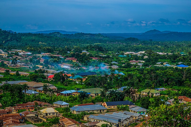
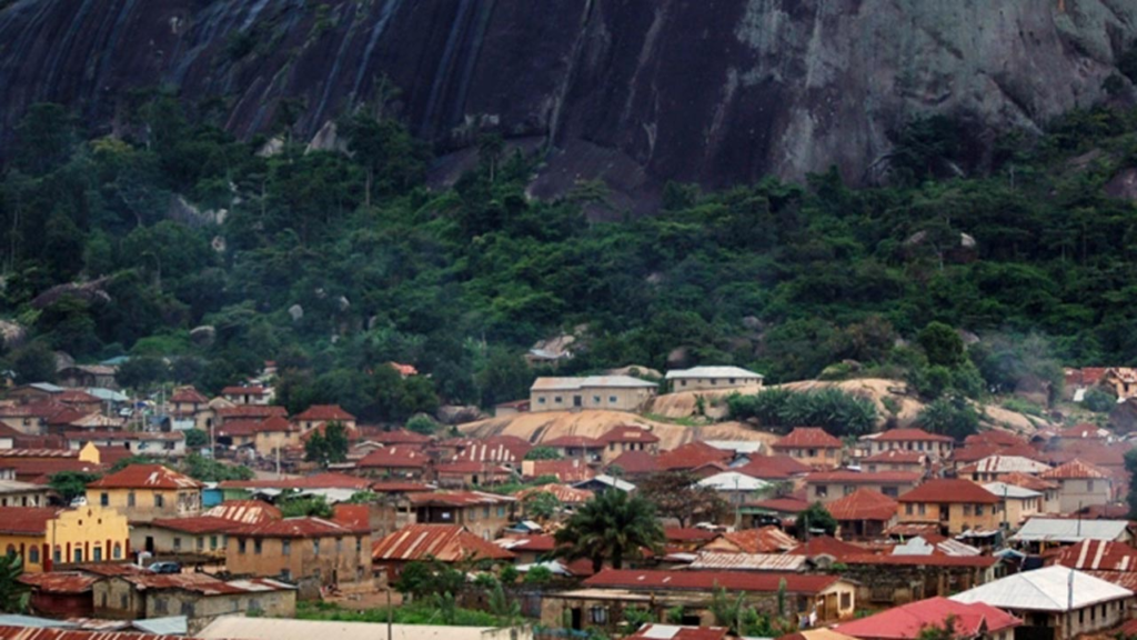
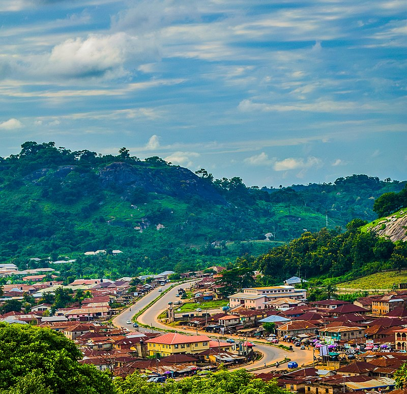
The State rises more than 250 meters above sea level and is mostly an upland region. It is situated on top of metamorphic rock. It is often an undulating region of the nation with a distinctive scenery made up of ancient plains interrupted by step-sided outcrops that may appear alone, in groups, or as ridges. These rock outcrops are mostly found in the Ekiti provinces of Aramoko, Efon-Alaiye, Ikere, and Igbara-odo. Rugged hills dot the state, with the Ikere-Ekiti Hills in the south, the Efon-Alaiye Hills on the western border, and the Ado-Ekiti Hills in the middle being particularly remarkable.
Climate and vegetation
There are two different seasons in the state’s tropical environment. These are the dry season (November–March) and the rainy season (April–October). High humidity and temperatures between 21 and 28 °C. The wet and dry (Harmattan) seasons are characterized by the northeast trade winds and the south westerly winds, respectively. The southern region is covered with tropical forest, while the northern margins are made up of savannah.
Local Government Areas
There are sixteen Local Government Areas in Ekiti State. As follows:
Ado-Ekiti
Ikere
Oye
Aiyekire (Gbonyin)
Efon
Ekiti East
Ekiti South-West
Ekiti West
Emure
Ido-Osi
Ijero
Ikole
Ilejemeje
Irepodun/Ifelodun
Ise/Orun
Moba
Current list of Local Government Area Chairmen
1 Ise/Orun: Hon. Olumide Falade 2 Gbonyin: Hon. Sade Akinrinmola 3 Emure: Hon. Oludare Paul Awopetu 4 Ido-Osi: Hon. Chief Ayodeji Arogbodo 5 Oye: Hon. Tayo Ogundare 6 Irepodun/Ifelodun: Hon. Dapo Olagunju 7 Ado-Ekiti: Hon. Deji Ogunsakin 8 Ikere: Hon. Bola Alonge 9 Ekiti South West: Hon. Lanrewaju Omolase 10 Efon: Hon. Bolaji Jeje 11 Ilejemeje: Hon. Ganiyu Bakare 12 Ijero: Hon. Abiodun Dada 13 Ekiti East: Hon. Samuel Adeniyi 14 Ekiti West: Hon. Kolawole Omotunde 15 Moba: Hon. Adeniyi Adebayo 16 Ikole: Hon. Adesola Adeyanju
Ekiti State’s proposed 18 Local Council Development Areas (LCDAs)
Prior to the resignation of the immediately preceding Governor Fayemi in 2014, the Ekiti State Government was mandated to establish an extra 18 LCDAs in accordance with the recommendations of the White Paper Committee that the government had formed. Governor Ayo Fayose, however, has canceled this.
Demographics
The Ekitis are a culturally uniform people that speak the Ekiti variety of the Yoruba language. Ekiti has considerable distinction among the states of the federation due to its homogenous makeup. The Yoruba dialects spoken by the border populations of neighboring states in Ekiti vary somewhat from each other. For instance, the residents of Ado local government area do not speak the exact same dialect as those in Ijero local government area, while those of Ikole local government area speak a dialect that is distinct from that of Ikere local government area. The Otun (Moba land) community, which speaks a dialect like that of the Igbominas in Kwara State, is one of the groups impacted by their geographic positions. The inhabitants of Oke-Ako, Irele, and Omuo share a dialect with the Ijesas of Osun State. However, one of the distinctive characteristics of the Ekitis is that, regardless of dialectal differences, no matter where you are in the state, you will be able to understand the other Ekiti[19] man or woman when they talk. A similar suffix, “Ekiti,” is added to the names of all towns in Ekiti State.
In Ekiti State, Christianity predominates, with sizeable Muslim and Animist minority.
Education
The 6-3-3-4 educational system is used in Ekiti State, Nigeria. The Ekiti State Universal Basic Education Board, which often collaborates with UBEC to guarantee the development of human capacity and infrastructure as described in the Universal Basic Education Policy, is in charge of overseeing elementary education. As it is applicable across Nigeria, the State Ministry of Education manages enrollment and upkeep in both private and public institutions from primary to secondary levels.
The first and still the oldest formal school in Ekiti State was founded in 1896 and is known as Emmanuel School (now Emmanuel Nursery and Primary School). The most well-known elementary schools in Ekiti State are Saint Joseph Nursery and elementary School, Ado-Ekiti, St. Louis Primary School, Ikere-Ekiti, Catford Nursery and Primary School, Ado-Ekiti, and EKSU Staff School. In Ekiti State, notable secondary schools include Christ’s School in Ado Ekiti, Petoa City College in Ado Ekiti, Ekiti Anglican Diocesan High School in Ado Ekiti, and Notre Dame College in Usi-Ekiti.
There are just four institutions in Ekiti State, and they are as follows: The Afe Babalola University, Ado-Ekiti, one of the top private universities in Nigeria, was founded in 2009 and has its main campus in the state capital of Ado-Ekiti. The public universities in Ekiti State include Ekiti State University, Ado-Ekiti, Federal University, Oye-Ekiti, and the recently founded Bamidele Olumilua University of Education, Science, and Technology, Ikere-Ekiti. The Federal Polytechnic, Ado-Ekiti, Crown Polytechnic, Ado-Ekiti, and College of Health Technology, Ijero-Ekiti are further postsecondary institutions in Ekiti State.
Politics
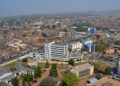
A democratically elected governor who works closely with the state’s house of assembly members is in charge of the state government. Ado-Ekiti serves as the state capital.
Electoral system
A modified two-round procedure is used to choose each state’s election system. A candidate must earn the majority of the vote and more than 25% of the vote in at least two-thirds of the State local government Areas in order to be elected in the first round. The top contender and the next candidate to win a majority of votes in the most local government Areas will compete in a second round if no candidate clears the threshold.
Natural resources
The country of Ekiti is naturally rich in many natural resources. The state may have abundant mineral reserves. These include, among others, gold coal in small quantities, granite, kaolinite, columbite, charnockite, iron ore, baryte, limestones, aquamarine, gemstones, phosphate, limestone, and tourmaline. They are mostly deposited in several cities and villages in the local government areas of Ijero, Ekiti West, Ado-Ekiti, Ikole, Ikere, Ise-Ekiti, and others.
Ero, Osun, Ose, and Ogbese are a few of the Land’s main rivers. The Land is also endowed with abundant water resources. The state of hills is also fortunate to have a wide range of tourism sites, including the Ikogosi Warm Springs, Arinta Water Falls, Olosunta and Orole Hills of Ikere, Erin-ayonugba River in Erijiyan Ekiti, Fajuyi Memorial Park of Ado – Ekiti, and others. The busiest and most advanced tourist destination is Ikogosi. The center has been created around the warm spring, a distinctive natural feature. A private corporation, UAC Nigeria, is now processing and bottling the spring’s water for commercial use.
Additionally, the area is rich in agricultural resources, with cocoa serving as the main revenue crop. Most people were aware that Ekiti land accounted for significantly more than 40% of the renowned ancient Western Region’s chocolate goods. As a result of Obeche’s popularity and economic importance, Triplochiton scleroxylon, which was designated as the State Tree in March 2022, the country is also noted for its abundant forest resources, particularly lumber. The terrain has luxuriant flora due to the favorable climatic conditions, which results in an abundance of diverse types of wood. Large amounts of food crops like yams and cassava are farmed, as well as cereals like rice and maize. Numerous fruit kinds and other famous crops, such kola nuts, are also grown in significant numbers commercially.


